

Introduction
Underground water does a three-fold action of erosion, transportation, and deposition like all other agents of change. A limestone area where underground water is more effective is known as ‘karst’ topography. It is named after a province of Yugoslavia.
Karst formation process
There are various physical, and chemical processes that take place while forming a karst topography. They are mentioned below
1. Chemical erosion
Karst landforms are produced by chemical weathering or chemical erosion of carbonate rocks mainly calcium carbonate (CaCO3, limestone) and magnesium carbonate (dolomites) by surface and subsurface water (groundwater).
2. Carbonic acid role
Limestone is soluble in rainwater which absorbs carbon dioxide from the atmosphere. When rainwater falls, the atmospheric carbon dioxide combines with it, and it turns into a weak acid called carbonic acid [water (H2O) + Carbon dioxide (CO2) = Carbonic acid]. The action of this acid on limestone produces a salt called carbonate. This acidic water, in the limestone region, sinks into the ground and dissolves limestone. It carves out a series of spectacular karst landforms.
Characteristics of karst landscape
- Karst landforms have a bleak landscape, occasionally broken by precipitation.
- Absence of surface drainage, as they percolate underground.
- Streams generally cut their way aloof the joints and fissures of the rock.
- They are porous and permeable in nature.
Sinkholes
- The most common and widespread topographic form in the karst region is the sinkholes.
- A sinkhole is a depression that varies in depth from 10 to 30 feet.
- It is a funnel-shaped depression that has an average depth of three to nine meters.
- They are developed by enlargement of the cracks found in such rocks, as a result of continuous solvent action of the rainwater.
- The best example is that of the limestone plateau of Kentucky in the USA where over 60,000 sinkholes are found.
Caves
- A cave is a natural underground chamber that opens to the surface.
- Caves form in the rocks made of limestone, marble, or dolomite that dissolve in acidic rainwater.
- As rainwater seeps underground it dissolves and washes away rocks in solution. The flowing water hollows out tunnels in rocks. Then the tunnels fill up with air and become a cave.
- The most famous cave in the world is Mammoth Cave in Kentucky, USA.
Cavern
- A large cave is called a cavern.
- A large limestone cave formed by solution due to underground water is known as a cavern.
- One example is Carlsbad caverns found in New Mexico, USA.
- Its depth is 12km.
Karst springs and rivers
A few features of karst springs are
- Karst spring is a part of the karst hydrological system.
- They are often conical or inverted bowl-shaped.
- They have a very high rate of yield or discharge rate.
- The largest karst spring is believed to be in Papua New Guinea (1).
A few features of karst rivers are
- They are the underground rivers of the karst topography.
- Karst rivers are also known as subterranean rivers.
- They flow beneath the surface of the earth at maximum times.
- Underground rivers emerge at sinkholes.
Tower karst and cone karst
Salient features of tower karst
- They are tall rock-like formations made up of soluble limestone in karst topography.
- They are spectacular landforms with 30-300 m high towers with vertical or overhanging sides.
- The most extensive tower karst is in the Guangxi province of Southern China.
Salient features of cone karst
- They are more common than tower karst topography.
- They are less spectacular and have limestone hills.
- They are typically covered with rainforests (2).
Surface landforms in Karst regions
There are various erosional and depositional landforms in karst topography. A few of them are
Poljes
More extensive than dolines, depressions are called ‘poljes’. They are characterized by vertical sidewalls, flat alluvial floors, independent surface drainage systems on their floors, irregular borders, and a central lake. Have an area of up to 258 Km2. They are frequently found in the karst region of erstwhile Yugoslavia and in Jamaica.
Uvalas
Uvalas are larger hollows and depressions than dolines. Several dolines merge together to form a large depression called uvalas. Smaller uvalas are called jamas. Some of them are 100 meters deep.
Biodiversity in the Karst habitats
Karst ecosystems often support unusual or rare plant and animal species, both on the surface and underground. Some ferns and mosses require limestone substrate on which to grow. Elk and deer use cave entrances during summer for breeding. Bats use caves for hibernation. Karst streams are richer in nutrients and safer for aquatic insect populations and fishes.
Cultural and Historical significance
The cultural importance of karst topography
In the past, karst played a significant role in the lives of many aboriginal peoples:
- Caves were often used for shelter, burial sites, and ceremonial purposes and karst springs were viewed as having special properties
- The large trees produced on karst sites were important sources of construction materials (dugouts, construction materials, totem poles, etc.). Karst sites were also a source of shrubs and herbs used for food and medicines
- Many present-day aboriginal cultures continue to value karst for ancestral, heritage, and cultural reason
The historical importance of karst topography
- Karst caves can be important sites for studying prehistoric living conditions because the natural environment (alkaline conditions, cool temperatures, the absence of light, difficult access) enhances preservation.
- Most of the known stone tools and skeletal remains of Homo neanderthalensis and early Homo sapiens are from limestone caves.
- The earliest known remains of humans in the Western hemisphere are found in US caves (3).
Challenges and Conservation
Impact of urbanization
- Rampant clearing of land resources to support the population is disturbing the karst regions.
- Rocky desertification of land is depleting the streams in karst topography.
- The dumping of urban wastes into the karst landforms creates pollution.
- Continuous use of groundwater in depleting the water-based sources of areas related to karst topography.
Population
- Usage of fuels, pesticides, herbicides, agricultural wastes, and other pollutants spilled on the surface in one part of a karst system can be rapid;y transported to drinking water sources.
- This affects human health as well as aquatic communities within karst systems.
- Contamination of karst waters can also occur when contaminants or pollutants from land use activities in upland non-karst areas are transported to the karst subsurface (4).
Deforestation
Deforestation means the cutting down or clearance of trees/vegetation. A huge rate of deforestation renders the topsoil loose which becomes prone to weathering and erosion at a faster rate. Hence the rampant clearing of vegetation from karst regions is slowly affecting the landforms.
Preservation, Development, and Protection
- Large-scale quarrying of limestone and dolomite from karst regions must be minimized.
- Mining of phosphate in karst caves where sinking creeks appear and disappear should be reduced.
- Touristic and land use practices must be controlled.
- Treatment of sewage from urban areas affecting the nearby karst landforms must be checked.
- Farming in karst regions must be prohibited.
- The usage of underground water must be done in a controlled way.
- Reducing the entry of eroded soil and other pollutants into surface watercourses.
- Avoid application of fertilizers, pesticides, or other chemicals in the vicinity of sinkholes, caves, etc.
- Waste management practices must be regulated in areas closer to karst.
- Manage caves to protect their natural values by ensuring that persons entering the cave behave responsibly.
Q&A
1. What are the five features of karst topography?
There are various erosional and depositional features of karst topography. Five of them are noted below-
- Solution holes
- Poljes
- Uvalas
- Caves
- Sinking creek
2. What are the four karst landforms?
The four major karst landforms are-
- Lapies
- Sinkholes
- Doline
- Swallow holes
3. Why is it called karst topography?
Landforms produced by chemical weathering or chemical erosion of carbonate rocks by surface and underground water are called karst topography.
Summary
- Karst is a topography formed with the dissolution of soluble rocks such as limestone, dolomite, and gypsum.
- It is characterized by underground drainage systems with sinkholes and caves.
- Ten percent of the earth’s surface is occupied by karst landscape.
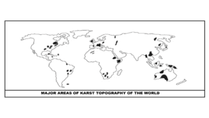
- The prominent karst regions are in Yugoslavia, region of southern France, western Cuba, west-central Kentucky, Virginia, Tennessee, and central Florida of the USA.
- There are various erosional landforms of karst topography such as blind valleys, disappearing streams, lapies, doline, caves, uvala, polje, etc.
- Depositional landforms of karst include- dripstones, drapes, stalactite, stalagmite, pillars, etc.
- Karst landforms have various biological, cultural, and historical significance.
- There should be more ways to preserve and maintain karst landforms from factors like pollution, deforestation, etc.
References
- Savindra Singh. Geomorphology. Pravalika publications, Allahabad. Chapter 22: Fluvial geomorphology. Page no: 437-440
- S. Lal. Physical geography. Sharda pustak bhawan, Allahabad. Chapter 14: The dynamics of river systems and their landforms. Page no- 214-218
- Rajiv Ahir. Spectrums Geography.Spectrum Books Pvt.Ltd, New Delhi. Chapter 18: Karst landforms and cycle of erosion. Page no: 85-87.
- Arun Shankar Pal. Higher secondary Geography. New book syndicate, Kolkata. Chapter 2: Work of groundwater and associated landforms. Page no: 15-17
- Anujbaran Sarkar. Higher secondary Geography. Oriental Book Company Pvt. Ltd. Kolkata. Chapter 1.2.9- Limestone or Karst topography. Page no: 12-16.