
Introduction
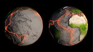
A fault line, also known simply as a fault, is a geological fracture in the Earth’s crust where two blocks of the Earth’s lithosphere (the rigid outer layer of the Earth) have moved relative to each other. These movements can be horizontal, vertical, or a combination of both. Faults are typically caused by tectonic forces and are a common feature in areas with active plate tectonics. There are many fault lines in the United States such as the San Andreas Fault, New Madrid seismic zone, Wasatch fault, Hayward fault, etc.
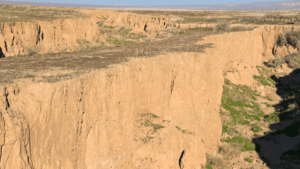
Before discussing fault lines, it is necessary to know about faults. A fault is a smooth fracture or difference in rock volume that causes a visible displacement of the rock and a change in the position of the rock. The fault line is a structural element of a fault.
A line along which the surface and the fault plane intersect is called the fault line. Fault lines of the United States are the earthquake-prone region (1) & (7).
Definition and Types of Fault Lines
Definition
The horizontal line along which the fault occurs is known as a fault line. It refers to the surface of cracks caused by landslides. This straight or curved line separates the surface and fault plane.
Types
1. Normal fault line
A fault in which the footwall rises up along the fault and the hanging wall sinks down along the fault line is called a normal fault, and the line along which this fault occurs is known as a normal fault line.
2. Reverse fault line
A fault line along which the hanging wall rises above the footwall due to compressive forces is called a reverse fault.
3. Strike-slip fault line
When the rock slides parallel to the strike of the fault, it is called a strike-slip fault and the line along which this fault occurs is known as a strike-slip fault line (7).
Major Fault Lines in the United States
There are some very dangerous long cracks or fractures (fault lines) located in the United States. The major fault lines of the United States are the San Andreas Fault, Hayward Fault, New Madrid Seismic Zone, Wasatch Fault, etc. A Brief description of these major fault lines is determined.
San Andreas Fault: Characteristics and Impact
Description
The San Andreas Fault line is the boundary or a line between two tectonic plates (the Pacific plate and the North American plate). It is one of the major fault lines in the United States.
In these eras when two tectonic plates, the Pacific and the North American plate move each other in opposite directions by the tectonic force, then the San Andreas Fault line was formed.
Characteristics
- The San Andreas Fault line is one of the largest fault lines in the world.
- These fault lines move at 5 to 7 centimeters a year.
- It divided California from Cape Mendocino to the Mexican border.
- The San Andreas Fault line is the longest fault line in the world. It is about 1287 km long.
- This fault line can also be seen from space.
- In the 1906 earthquake, the parts of the fault line moved as much as 6 meters.
Impact
- Tectonic movement along the San Andreas Fault line has been associated with large earthquakes near the surface, including an earthquake in San Francisco in 1906, a severe event in 1989, and a powerful earthquake in Los Angeles in 1994.
- There was tectonic movement along the San Andreas Fault that caused seismic waves throughout the state of California, leveling old buildings, disrupting roads, and severing electrical, telephone, and water lines.
- All power lines, gas pipes, and water lines that cross these fault lines were broken during the earthquake.
- Many old house structures have become unusable.
- The financial crises, food crises, etc. are seen and human life is disrupted (1).
New Madrid Seismic Zone: History and Seismic Activity
History
The New Madrid seismic zone is also known as the New Madrid fault line. This fault line is about 45 miles wide and about 125 miles long.
This zone is located in southeastern Missouri, northeastern Arkansas, western Tennessee, western Kentucky, and southern Illinois, east of the Rocky Mountains. It is also a most active tectonic movement area. The new Madrid fault line is located near the center of the North American plate.
Seismic activity
In United States history, this region has four of the largest earthquakes. All of these earthquakes had a magnitude of 7.0 or more than 7.0. All the earthquakes occurred in the 3 months between December 1811 and February 1812. An average of about 200 earthquakes occur each year, although their tectonic activity is mostly barely felt. The last strong earthquake occurred in the New Madrid seismic zone on 31 October 1895. Other notable earthquakes were recorded in 1843 and 1895 (5).
Cascadia Subduction Zone: Geology and Potential Risks
Geology
The Cascadia Subduction Zone is a fault line located about 112-160 km off the Pacific coast. It extends from northern Vancouver Island in Canada to northern California in the United States. This fault line can produce 9.0 or more than 9.0 magnitude earthquakes. It is a very long, sloping subduction zone. These fault lines include Vancouver and Victoria, British Columbia, Seattle, Washington, and Portland, Oregon.
Potential Risks
- The new research says a major earthquake with a magnitude greater than 9.0 would occur in the Cascadia subduction zone.
- There is a 40% chance of a magnitude about 7.5 magnitude earthquake on this fault line occurring in the next 50 years.
- This tectonic movement will be felt across the Pacific Northwest.
- In new research, it says that the Cascadia subduction zone earthquake could injure about 27,000 people, and displace 80,000 people (4).
Hayward Fault: Location and Seismic Hazards
Location
Hayward fault is located nearly 45 miles through the east bay of the San Francisco Bay region. This fault line passes through Richmond, El Cerrito, Berkeley, Oakland, San Leandro, and Castro Valley.
Seismic Hazards
- The Hayward fault line was formed by the movement of the North American plate and Pacific plates.
- This fault line is known for its involvement in the 1868 earthquake.
- The largest earthquake on the Hayward fault occurred in 1868. Its magnitude was 7.0. This earthquake occurred on the southern part of the fault line (6).
Wasatch Fault: Tectonic Features and Geological Significance
Tectonic features
The Wasatch fault line is a normal fault line. It can be found at divergent boundaries. This fault line forms a boundary between the North American plate and the subducted crust of the Great Basin and ranges to the west.
Geological Significance
- The Wasatch fault line is an active fault line.
- It was originally located on the western edge of the Wasatch Mountains in the US states of Utah and Idaho.
- This fault line is about 240 miles long.
- It has been active for about 15 million years (2).
Rio Grande Rift: Formation and Geological Processes
Formation
The Rio Grande rift was formed about 35 million years ago when the earth’s crust stretched and thinned during westerly directed extension. This fault line was formed in a divergent boundary where three tectonic plates meet at 120° angles.
Geological processes
- The largest earthquake in the Rio Grande Rift was in 1887.
- It occurs near Sonora, Mexico. The magnitude of the earthquake in the region was 7.5.
- This fault is generally moving in a clockwise direction, from the North American plate.
- The Rio Grande rift formed in central Colorado in the north to the state of Chihuahua, Mexico, in the south.
- It is North America’s largest rift. This rift is 1000 m long.
- This zone is a north-trending continental fault zone.
- Rio Grande rift consists of three main basins and many smaller basins (3).
Lesser-Known Fault Lines in the United States
The Ramapo fault zone is a lesser-known fault line in the United States.
Monitoring and Predicting Earthquakes along Fault Lines
- Earthquakes are monitored by a seismometer.
- The seismometer is connected to a seismograph. It records the motion of the mass during an earthquake, which is known as a seismogram.
- Some methods have been tested in an attempt to learn how to predict earthquakes in fault lines. These are seismic changes, seismic wave speed changes, electrical changes, and groundwater changes.
Preparedness and Mitigation Strategies for Fault Line Areas
Before an earthquake in the fault line
- The area must be researched.
- Find out if there is an active fault line.
- To check whether the surrounding soil is more sensitive to earthquake effects.
- Be aware of seismic hazards as well etc.
During an Earthquake in the fault line
During the earthquake, the debris of various houses, furniture, etc. collapsed. It needs to stay away from them. Some steps to be taken for this are-
- Get down the hands and knees. It can help to protect various important organs.
- Do not go outside when earthquakes occur.
- Shelter on a table or desk.
- Put the hand on the back of the head and neck etc.
After an earthquake in the fault line
- Check the gas line and pipeline.
- As a result of the earthquake, the furniture of the house was broken on all sides. So shoes should be walked around until the floor is clean and safe.
- Be prepared for an earthquake’s aftershock. Aftershocks are additional earthquakes that follow the main earthquake.
Q&A
1. Where are the fault lines in the United States?
- San Andreas fault
It is located in California, Baja California, and Sonora in the United States.
- New Madrid Fault line
Located in southeastern Missouri, northeastern Arkansas, western Tennessee, western Kentucky, and southern Illinois.
- Wasatch fault
It extends from north of Malad City, Idaho to south of Fayette in central Utah.
- Ramapo fault zone
This fault line is located in New York, New Jersey, and Pennsylvania.
2. What is the major fault line in the US?
The San Andreas Fault line is the major fault line in the US.
3. Who has the biggest fault line in the world?
The biggest fault line in the world is the San Andreas Fault line in California.
4. Where are the most active fault lines?
The most active fault lines are located in the United States.
Summary
- A fault line is a long crack or fracture in the surface of the earth. Earthquakes usually occur along these fault lines.
- It is a horizontal plane that indicates the surface of a fault.
- Mainly the biggest earthquakes occur along these fault lines.
- There are various types of fault lines located in the United States. These are the San Andreas Fault line, Wasatch fault, Ramapo fault zone, Cascadia Subduction Zone, New Madrid Seismic Zone, etc.
- The San Andreas Fault line is the world’s largest fault line. It is 1200 km long.
- Around 30 million years ago, the San Andreas Fault line was formed in the late Mesozoic and early Cenozoic eras.
- According to the geologist, the New Madrid faults were caused by pressure from the Mississippi River eroding the surrounding landscape 10,000 to 16,000 years ago.
- Juan de fuca and gorda plates in the Cascadia subduction zone, move towards the east and slide below the North American plate. The last earthquake that occurred in the Cascadia subduction zone was on January 26, 1700.
- Rio Grande Rift was also an active Fault line. The biggest earthquake occurred in this region in 1887 (magnitude 7.5).
- The latest earthquake occurred in the Hayward fault line on 8th July 2021. Its magnitude was 6. This earthquake struck 152 miles east-northeast of Hayward.
- A magnitude 7.9 earthquake also hit the Wasatch fault lines (1) & (7).