

Know in one minute about Depositional Landforms
|
Introduction
Depositional landforms are geological features that are created by the deposition or settling of sediments like (sand, silt, clay, rocks, and organic matter), often by natural forces like wind, water, ice, gravity, etc.
What are depositional landforms?
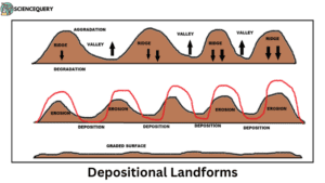
The material eroded by the process of degradation is deposited in the depressions or lowlands and these areas rise up. This process is also known as aggradation. It is a process in which the land surface is built up by the process of deposition and accumulation of debris, rock fragments, clay, sand, rock waste, and alluvium derived from transportation and denudation. The agents of aggradation or deposition are the same as those of erosion.
Depositional landforms can be of various types such as fluvial(river), aeolian(wind), glacial, underground water, and coastal.
Characteristics
- Depositional landforms are formed by the gradual buildup and accumulation of sediment materials.
- Depositional landforms have gentle slopes.
- They have very distinctive and dominant shapes.
- Sedimentary layers, or strata are often visible in depositional landforms.
- Over time vegetation cover can be noticed in depositional landforms.
- Have adjoining features such as alluvial fans, cones, alluvial plains, meanders, etc.
- They have a very fertile soil due to the accumulation of sediments.
- Are agriculturally very productive.
- Depositional landforms give a brief description of Earth’s geological history and significance.
Formation
There are various geological and natural processes involved in the formation of depositional landforms. They are mentioned below.
-
Erosion
It is a process by which natural agents like water, wind, ice, and gravitational force remove and transport sediments from one place to another. During erosion, these agents dislodge, separate, and carry away sediments from their prime area, like mountains, cliffs, etc.
-
Transportation
As sediments are eroded by agents like water, air, etc, they are transported downstream or downwind. The speed and energy of the transporting agents play a crucial role in determining when, how far, and in what manner the sediments are carried.
-
Deposition
When the energy of the transporting agents decreases, they become less capable of carrying the sediments. As a result, the sediments accumulate in specific areas, which gives rise to depositional landforms.
Coastal Depositional Landforms
A few coastal depositional landforms are mentioned as follows-
-
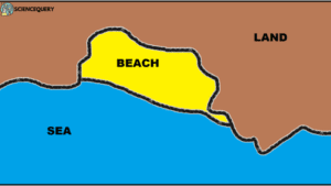
Beach
The beach is formed due to the deposition of sand, gravel, and pebbles on the shore between the low tide level and the coastline. Examples are Waikiki beach, Hawaii, USA, and Bondi beach, Australia.
-
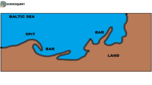
Spit
It is a ridge or embankment of sediments deposited by the waves and attached to the land at one end and projecting into the open sea at the other. Examples are Spurn Point, the east coast of England.
-
Bar
A bar is a sort of embankment of sand and gravel built by the depositional work of sea waves. Examples are the Outer Banks of North Carolina, USA.
Fluvial Depositional Landforms
Few of them are mentioned as
-
Alluvial fans
These are fan-shaped landforms formed at the base of steep mountain slopes. It deposits sediments like gravel, and boulders creating a cone-shaped fan. Example– Death Valley National Park, California, USA.
-
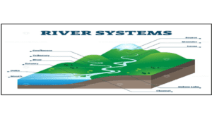
Deltas
They are triangular or fan-shaped landforms formed at the mouths of rivers where they meet standing water bodies. Examples are the Nile Delta and the Senegal Delta.
-
Natural levees
these are raised banks or ridges of sediment that form parallel to a river’s channel. Examples are levees built along the Mississippi River and Sacramento River in the USA.
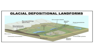
Glacial Depositional Landforms
Few landforms created by the deposition of sediments in glaciers are-
-
Moraines
When the glacier melts, it starts depositing its sediments known as moraines. Examples are Kettle Moraines, Wisconsin, USA, Harbor Hill Moraine, and Long Island, NY, USA.
-
Drumlins
These are peculiar types of low round hillocks that resemble the shape of an inverted half-egg. Examples are Southern Ontario and Long Island.
-
Outwash plains
They are flat, open areas of sand and gravel that extend beyond the glacier’s terminus. Examples are The Bollnas Outwash Plains, Sweden.
Desert Depositional Landforms
There are various landforms created by the deposition of sand in desert regions by forces of wind. Some of them are-
-
Sand dunes
It is a mound, a hill, or a ridge of sand with a crest or a definite summit. They can be as high as 300 meters. Examples are Badain Jaran Dunes, China, the Great Dune of Pyla, France, etc.
-
Sand shadow
Formed under harsh conditions behind hills, the mature sand shadow dunes are hundreds of meters long and have significant ridges. Examples are Jockey’s Ridge State Park, North Carolina.
-
Loess
It is a German word used for deposits of fine-grained, coherent, friable, porous, and yellowish dust deposited by wind. Examples are the Loess of North China, North America, and parts of Africa.
Human Human-induced depositional Landforms
Some landforms are either created or altered by humans and few of them are (1).
- Landfills: these are artificial landforms created by the deposition of waste materials like household trash, and industrial and construction debris.
- Reservoirs: these are dams constructed for water supply, hydroelectric power generation, or irrigational purposes by humans.
Importance and Impact
- They provide a record of early geological conditions and the Earth’s movement.
- They create a unique habitat for diverse animal and plant species.
- Fertile soil found in various fluvial depositional features is very important for agriculture.
- Some glacial and fluvial depositional landforms allow rainwater and snow to infiltrate and recharge the groundwater levels.
- They are a hotspot of tourism and recreation.
- They provide opportunities for scientific research and education.
Q&A
1. What are some good questions to ask about landforms?
A few good questions to ask about landforms are-
- What do you mean by depositional landforms?
- What are the major types of depositional landforms?
2. What is the most common depositional landform?
The most common depositional landforms are-
- Beach
- Alluvial plains
- Deltas
- Floodplains
- Sand dunes
3. How does deposition create new landforms?
Landforms are created by the deposition of sediments such as sand, silt, clay, rocks, etc in particular locations on the earth’s surface by the action of natural agents like wind, water, ice, and gravity.
4. Where are depositional landforms more likely to form?
They are most likely to form near water bodies, hence fluvial depositional landforms like floodplains, and alluvial fans are most widespread.
References
- D.S Lal. Physical Geography.Sharda Pustak Bhawan,Allahabad. Chapter 12: Weathering and mass movement. PP: 147-152.
- D.S Lal. Physical Geography.Sharda Pustak Bhawan,Allahabad. Chapter 19: Glaciers and glacial topography. PP: 238-254.
- D.S Lal. Physical Geography.Sharda Pustak Bhawan,Allahabad. Chapter 18: Landforms shaped by waves and currents. PP: 221-237.
- D.R.Khullar. ISC Geography.Kalyani Publishers, Kolkata.Chapter 9: Exogenous processes and associated landforms. PP: 150-156
- D.R.Khullar. ISC Geography.Kalyani Publishers, Kolkata. Chapter 11: Fluvial process and associated landforms. PP: 173-187.
- D.R.Khullar. ISC Geography.Kalyani Publishers, Kolkata. Chapter 15: Marine processes and associated landforms. PP: 222-232.
- Savindra Singh.Geomorphology.Pravalika Publications, Allahabad. Chapter 25: Arid and semi-arid geomorphology. PP: 463-477.
- Savindra Singh.Geomorphology.Pravalika Publications, Allahabad. Chapter 30: Anthropogenic Geomorphology. PP: 564-589.