

Introduction
A group of visible crystals or condensed water particles or vapor floating in the upper atmosphere of the earth are known as clouds. The upward wind expands as the pressure decreases and cools to form clouds. There are different types of clouds in the atmosphere depending on height and other factors. Below is a discussion of different types of clouds and their importance.
- The formation of clouds occurs via condensation.
- Thus there are different types of clouds depending upon the types of condensation.
- If the wind rises rapidly and condenses, then the vertical development of the clouds is very high.
- And if the wind rises slowly to the top and causes condensation, then the clouds spread horizontally.
- Clouds control the earth’s terrestrial heat budget, air temperature, and so on.
- The heat of the lower atmosphere is also transmitted through the clouds to the upper atmosphere. This results in climate change.
- The weather can be predicted according to its characteristics. For this reason, the discussion of different types of clouds in climatology is very important (1).
Types of clouds
The temperature decreases with the increase in elevation. This is because with increasing altitude the pressure decreases and thus the molecules of air spread out further or we can say they expand resulting in a temperature drop. The water evaporates in the form of vapor due to the sun from the surfaces of the ocean, rivers, and other water bodies.
This vapor becomes lighter than the air thus rising up and cooling down at one level into tiny water particles and floating in the air thus forming a cloud (1).
The world meteorological organization has divided all types of clouds into ten genera. However, according to the height, all types of clouds are classified into four families (2) these are as follows
1. High clouds
High clouds are located at an altitude of about 6097 to 12,350 meters. Clouds at this level are known as Siro. Such clouds are white and spread across the sky like feathers. High clouds are divided into three types based on the shape
a. Cirrus
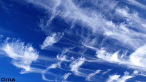
- Cirrus clouds look like the feathers of a bird or the scratch of a painted brush or the tail of a horse.
- These are the highest clouds in the sky.
- They are quite white.
- These types of clouds indicate clear weather when they are scattered in the sky.
- The symbol of the cirrus cloud is Ci.
- In daylight, this cloud looks like a white feather, but in the sunset, this cloud has a wonderful color.
b. Cirrocumulus
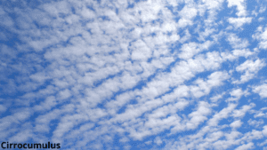
- These clouds can be seen in small rows or waves.
- The color of this cloud consisting of tiny snowflakes is white. But sometimes it appears gray in color.
- When this cloud spreads across the sky, it is called the mackerel sky.
- The symbolic name of this cloud is Ci-cu.
- These clouds usually do not cast shadows.
- They look like small rounded puffs.
- This type of cloud is rarely seen in the sky.
c. Cirrostratus
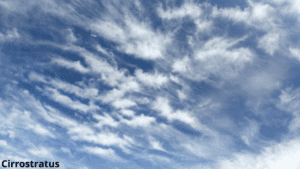
- This cloud is located below the Cirro-cumulus cloud.
- Such clouds are white, quite light, and transparent.
- Cirrostratus clouds are located all over the sky.
- It is a kind of transparent cloud that forms a halo or circle around the sun and moon.
- The symbolic name of this cloud is Ci-st.
- This cloud-covered sky looks milky white.
- The way to recognize these clouds is that they are in a circle around the sun.
- These clouds are found at an altitude of 20,000 to 43,000 feet above the atmosphere.
- The presence of these clouds can be noticed when there is a lot of moisture in this layer of the atmosphere.
2. Mid-altitude clouds
Mid-altitude clouds are located at a height of 2 km to 6 km in the sky. Clouds of this genera are mainly composed of water particles. However, sometimes when the temperature drops too low, a mixture of water particles and ice particles can be seen in these clouds. Occasionally there is precipitation from these clouds. The height of such clouds is 6000 to 20,000 feet. There are two types of Mid-altitude clouds. These are
a. Altocumulus
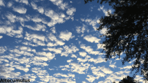
- These clouds are shaped like round bunches of fur.
- The color of this cloud is gray.
- These clouds are sometimes arranged in rows.
- Altocumulus clouds are very deep because the wind blows upwards through them.
- These clouds are mainly composed of water particles.
- When the temperature of these clouds drops considerably, water particles and snowflakes can be seen in these clouds.
- They are shaped like lenticular.
- Sometimes it rains from altocumulus clouds but that rain does not always reach the earth.
- The symbolic name of the altocumulus cloud is Alt-cu.
b. Altostratus
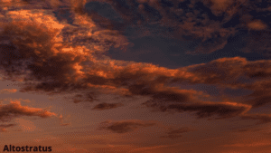
- Altostratus clouds are located in layers below the cumulus clouds.
- The color of these clouds is gray or bluish-gray.
- Sometimes it rains from these clouds.
- The symbolic name of this cloud is Alt-st.
- Clouds of this genera also create light around the sun and moon.
- This cloud is much thicker and darker than the Cirrostratus cloud.
- Like a sheet, these clouds float across the sky.
- Through these clouds, the rays of the sun come in faintly and make the sun appear dim.
3. Low clouds
The maximum height of this cloud is 6500 feet. These clouds are made up entirely of water particles. However, in the winter in the central and upper regions, the location of these clouds is snow. Lower clouds are divided into three classes. These are
a. Stratocumulus
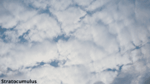
- The colors of these clouds range from gray to black.
- Symbolic name of this cloud is St-cu.
- During the winter in temperate regions, these clouds often cover the entire sky.
- These clouds are lined up in heaps at a height of one to two km.
- Stratocumulus clouds are sometimes called stratospheric clouds.
- There is very little rainfall from this type of cloud.
- The altocumulus cloud in the middle of the sky becomes heavier and denser and forms these clouds.
- Many times it looks like the layers of clouds are rolling, hence the name of these clouds is bumpy cloud.
- They can transform into nimbostratus clouds.
b. Nimbus or nimbostratus
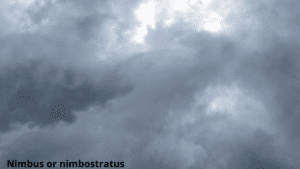
- Clouds of this class are located below the stratocumulus clouds.
- The color of nimbus clouds is more dense and black.
- These clouds cause continuous light to moderate rainfall.
- Although the intensity of rainfall is low, the amount of rainfall from such clouds is much higher as it rains for a long period of time.
- These clouds are shapeless and have hairy layers in many cases.
- The symbol for this cloud is Ni-st.
- Such clouds never cause lightning, thunderstorms, or hail.
- Nimbostratus cloud is called the rain cloud.
- This cloud is so dense that the sun cannot be seen if there is this cloud in the sky.
c. Stratus
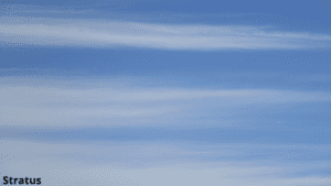
- These clouds are white in color.
- Clouds of this class are closest to the earth’s surface.
- They are arranged in layers so they are called stratus clouds.
- These horizontally wide gray clouds cover the entire sky.
- This type of cloud is formed when fog rises near the ground or when the deep fog clears the bottom.
- Stratus clouds can sometimes cause light rain.
- The symbolic name of this cloud is St.
4. Vertically clouds
The clouds of this genera extend only vertically. These clouds never cover the white sky. Rather, they are isolated in the sky. The two types of clouds that can be seen in this class are
a. Cumulus
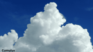
- The word cumulus means heap. This cloud is always seen spreading vertically.
- A cumulus cloud is a thick cloud that extends vertically like a tower.
- The upper part of these clouds is as wide as cauliflower.
- These clouds can be seen on the land during the day.
- The presence of convection currents can be noticed in these clouds.
- Bright sunlight can be seen through these clouds.
- The symbolic name of this cloud is Cu.
- When these clouds gather in the sky, there is clear weather.
- These clouds look bright white at sunrise, but the lower part of the cloud is flat and black.
- Cumulus clouds gradually grow larger to form cumulonimbus clouds.
b. Cumulonimbus
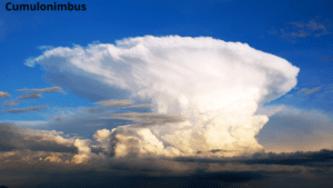
- The cumulonimbus cloud is one of the important clouds among the low, medium, and high clouds.
- Clouds of this class are very deep, dense, black, and huge in size.
- These clouds spread eastward due to the influence of westerly winds in the upper winds.
- These clouds look like a dome with a flat shape at the top and a flat shape at the bottom of the cloud.
- Cumulonimbus clouds are white, gray, and black.
- These types of clouds are usually lightning clouds.
- Natural disasters including hailstorms, and tornadoes tend to be these clouds.
- If the cumulonimbus clouds in the sky, the next weather is going to be bad, that is, there may be heavy rain and hail (1) & (3).
Importance of each cloud
-
Cirrus
One of the most important cirrus clouds is clear weather. However, if the cirrostratus clouds are seen after this cloud, then it must be understood that the storm is coming.
-
Cirrocumulus
The weather is very pleasant when there are Cirro-cumulus clouds in the sky.
-
Cirrostratus
These clouds carry storm signals. Such clouds can be seen in the sky before the cyclone. In the language of astronomy, the circle that is seen centering the sun in the sky is called the sun halo. Cirrostratus clouds create this kind of halo.
-
Altocumulus
Altocumulus clouds always indicate clear weather. Behind such clouds, light is created around the sun or the moon. It is called corona. The occasional blue sky can be seen in these clouds. These clouds are often seen in warm and humid weather on summer mornings.
However, on a day when there is a possibility of thunderstorms and rain, this cloud can be seen in the morning. These clouds in many cases signal the onset of cool temperatures.
-
Altostratus
One of the importance of this type of cloud is that it usually predicts continuous rainfall over the cloud. Such clouds can be seen before storms or snowfall. The stability of rainfall caused by these clouds is much higher. This cloud gives the forecast of a storm.
-
Stratocumulus
Much of the earth’s surface is covered by stratocumulus clouds, making them more important for the earth’s energy balance than any other cloud type, primarily through the reflection of solar radiation.
-
Nimbus or nimbostratus
Nimbostratus clouds are clouds that form temperatures in the atmosphere. It produces snow and rain. There is usually very light rainfall from these clouds.
-
Stratus
There is very little rainfall from the stratus cloud. But sometimes when these clouds are thick, light drizzles. It absorbs heat emitted from the earth’s surface and cools and warms the atmosphere.
-
Cumulus
In most cases, cumulus clouds indicate clear weather and bright sunny days. However, if conditions permit, cumulus clouds can turn into strong cumulonimbus clouds, which can create rain.
-
Cumulonimbus
This type of cloud is important for thunderstorms and lightning and torrential rains. The wind blows with the rain. Sometimes hail also falls from these clouds. Nor wester storms are caused by such clouds (2) & (3).
Q&A
1. What are the different types of clouds?
According to the height, all types of clouds are classified into four families. These are
- High cloud
- Cirrus
- Cirro-cumulus
- Cirro-stratus
- Middle cloud
- Altocumulus
- Altostratus
- Low cloud
- Stratocumulus
- Nimbus or nimbostratus
- Stratus
- Vertically cloud
- Cumulus
- Cumulonimbus
2. What are the types of clouds?
There are 10 types of clouds. These are Cirrus, Cirro-cumulus, Cirro-stratus, Altocumulus, Altostratus, Stratocumulus, Nimbostratus, Stratus, cumulus, and Cumulonimbus.
3. How many types of clouds are there?
There are 4 types of clouds. These are-
- High cloud
- Cirrus
- Cirro-cumulus
- Cirro-stratus
- Middle cloud
- Altocumulus
- Altostratus
- Low cloud
- Stratocumulus
- Nimbus or nimbostratus
- Stratus
- Vertically cloud
- Cumulus
- Cumulonimbus
4. Which of the following types of protogalactic clouds is most likely to form an elliptical galaxy?
A dense cloud with very low angular momentum is most likely to form an elliptical galaxy.
5. What are the 3 types of clouds?
Cumulus, Cirrus, and stratus are the three main types of clouds.
Reference
1. Savindra Singh. Climatology. Pravalika Publications, Allahabad. Chapter 2: Origin, composition, and structure of the atmosphere. Page No: 20.
Written By: Manisha Bharati