Introduction
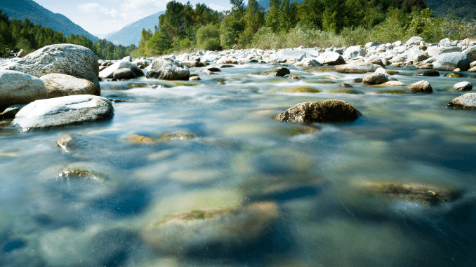
The river is the most important of all geomorphic agents. Its work is widespread and covers a large area on the earth’s surface. In all types of landforms, rivers play an important part. The landforms created as a result of erosional action or depositional action of rivers are called fluvial landforms.

What is Fluvial erosion?
The word erosion has been derived from the Latin word “erodere” which means to gnaw (to nibble something continuously). Hence erosion is the process in which various erosive agents (running water, wind, glaciers, sea waves, and groundwaters) obtain and remove rock debris from the earth’s crust and transport it for long distances.
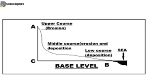
The landforms either carved out due to erosion or built up due to deposition by running water are called fluvial landforms, and the running waters that shape them are called fluvial processes. The geological works of fluvial processes of rivers are called three-phase work comprising erosion, transportation, and deposition.

Vital roles of Fluvial erosion
Moving water erodes all earth’s surface materials, not only along the bed of a river but also the sides of the channel.
- The river transports all the eroded materials onto a new location and then deposits them.
- Fluvial erosion helps in the creation of new landforms found on the surface of the earth.
- It also erodes landforms that have been in existence since time, thus creating space for new landforms.
- Since time immemorial human settlement has been settling around various fluvial landforms.
Dynamics of the river current
The erosional work of the rivers depends upon the velocity of the river, water discharge, river load, and various other factors. At any one moment, about 1250 km3 of water flows through all the rivers on the earth’s surface. Actually, the river transports only 0.003% of all freshwater, but the work done by them is the most important. The law of erosion states that the rate and amount of erosion increase when the load is low. The following relationships may be identified between the rate of fluvial erosion and river load-
- Erosion becomes minimal in the absence of the required amount of river load (underloaded river)
- Erosion also becomes minimal when the river has a maximum load (overloaded river)
- Erosion becomes maximum when the river carries a load according to its transporting capacity.
Hydraulic action of the river
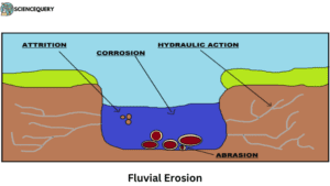
It involves the breakdown of the rocks of valley sides due to the impact of water currents of the channel. In fact, hydraulic action is the mechanical loosening and removal of materials of rocks by water alone. The pressure and drag of flowing water exerted upon grains projecting from the bed and banks results in hydraulic action. Weak bedrock and various forms of regolith are easily carved out by hydraulic action.
Erosion process
The erosional work of the rivers is performed in two ways-
- Through chemical erosion: it involves the corrosion or solution, carbonation.
- Mechanical erosion: it comprises corrosion or abrasion, hydraulic action, and attrition.
A few processes are mentioned below:
Abrasion
It involves the removal of loosened materials from the rocks of valley walls and valley floors with the help of erosional tools (boulders, pebbles, cobbles, gravels, etc). The erosional tools or river loads move down the channel gradient along with water and thus strike against the rocks that come in contact with them. The repetition of this mechanism weakens the rocks which are ultimately loosened and broken down. Thus abrasion is the mechanism of breakdown of rocks occasioned by erosional tools carried by the rivers.
Attrition
It is the mechanical tear and wear of the erosional tools in themselves. The boulders, cobbles, pebbles, etc. while moving with water collide against each other and thus are fragmented into smaller and finer particles in transit. Thus, the rock particles are so broken down that ultimately they are comminuted into coarse to fine sand particles which are transported down the channel in suspension.
Solution
Also known as corrosion, involves the dissolution of soluble materials through the process of disintegration and decomposition of carbonate rocks. The soluble materials are removed from the parent rocks and are mixed with the running water on streams.
Fluvial Erosions Types
The following three types of erosion by the river are normally recognized-
1. Headward Erosion
This is the process of cutting back upstream of a valley above its original source by rainwash, gullying, and spring-sapping. Thus, the source of the stream gradually recedes and ultimately may notch the ridge that forms the original watershed. This may ultimately lead to river capture.
2. Vertical Erosion
When the river cuts the rock material in a vertical direction that is, when the river is engaged in downcutting, it is called vertical erosion. This leads to a deepening of the river valley.
3. Lateral erosion
This takes place when the river cuts the sides of its valley. Lateral erosion results in the widening of the river valley
Landforma shaped by Fluvial erosion
The significant landforms resulting from fluvial erosion by the river are mentioned below-
1. Canyons
These are the extended forms of gorges. Canyons represent very deep, narrow but long valleys. The steepness of the valley sides depends on the nature of the rocks. Relatively resistant rocks support steep valley sides whereas resistant rocks alternated by soft rocks give birth to undulating valley sides.
Examples: The Grand Canyon of the Colorado River in the state of Arizona, USA, having a length of 482.8 km and a depth of 2088.3 m is one of the most important canyons in the world.
2. Meanders
A meander is defined as a pronounced curve or loop in the course of a river channel. The outer bend of the loop in a meander is characterized by intensive erosion and vertical cliffs and is called the cliff-slope side. This side has a concave slope. The inner side of the loop is characterized by deposition, a gentle convex slope known as a slip-off side. Morphologically the meanders may be wavy, horse-shoe type, or ox-bow bracelet type.
Examples: River Derwent, North Yorkshire, rivers in the Colorado Plateau, the Kentucky River Palisades in central Kentucky, etc.
3. V-shaped valleys
The valleys carved out by the rivers are significant erosional landforms. The valley formed in the youthful stage of a fluvial cycle of erosion and in the initial stage of valley development is V-shaped having a steep side slope and convex element. The valley is very deep and narrow formed by the downcutting.it is further classified into gorges and canyons.
Examples: Grand Canyon in the Southwest of the United States of America.
Factors Influencing Fluvial Erosion
There are several factors that help influence the level of fluvial erosion, a few of them are mentioned below
1. Geological Impact
- The erosional work of a river depends upon the velocity of water in the river
- The increase in the volume of water in a river increases its capacity to erode.
- Soft rocks such as limestone and sandstone are eroded easily by the river whereas the river takes a long time to erode hard rocks.
- The running water by itself is a primary agent which influences erosion.
2. Human Impact
- Removal of trees and cutting down of forests by humans renders the topsoil loose, hence fastening erosion.
- Construction of bridges and dams on rivers and lakes changes the course of the river, thus influencing erosion.
- Modifying streams and lakes into a certain pattern majorly affects floodplains.
- Dumping of different hazardous materials by humans severely affects the rate of fluvial erosion.
3. Climate change
- Heavy rainfall due to climate change increases the rate of erosion.
- Continuous rainfall can lead to deposition of sediments into rivers and lakes, thus slowing down erosional processes.
- A rise in sea level leads to flooding which in turn upsets the fluvial system.
Long-Term Evolution of Fluvial Erosion
Fluvial erosion is a continuous and evolving process that has been happening since time immemorial. Few factors are
Impact over mountains
Fluvial erosion helps in the creation and formation of mountains in many ways. As we know, the majority of rivers of the world have originated from mountains, thus fluvial erosion shapes the mountain systems and improves the surrounding landform. It also reduces the height of the mountains which accelerates tectonic movement below the earth’s surface.
Role of Fluvial erosion on geological records
Various landforms have been created by the process of fluvial erosion and deposition in all the stages of the river. Some great examples are Grand the canyon in the USA(canyon), Niagara Falls in North America(waterfalls), Alluvial cones in Death Valley, Meander River in Turkey(meanders), etc.
How to manage Fluvial erosion
The process of fluvial erosion is a dynamic and natural process and hence cannot be managed completely by anthropogenic forces, still, some ways to manage are stated below
Sustainable river management concept
Sustainable management of rivers involves cooperation between countries and states sharing the same river basin and cooperation between government and all stakeholders. Internationally, countries need to negotiate and use rivers as the basis for peace rather than conflict (1).
Conservation efforts
Construction of banks and dams on river and river basins, coverage of the area by natural vegetation, etc are some ways to control fluvial erosion.
Engineering techniques
Some scientific ways to control fluvial erosion are enriching the soil with organic matter, reducing water flow speed, improving irrigation practices, making engineering constructions on river banks, etc.
Q&A
1. What is fluvial erosion?
The wearing or breaking down of landforms due to high-flowing conditions of a river is known as fluvial erosion.
2. What are the four types of fluvial erosion?
The four main types of river erosion are- hydraulic action, attrition, corrosion, and abrasion.
3. What is an example of fluvial erosion?
One prominent example of fluvial erosion is the Grand Canyon located in Arizona, USA
4. What is fluvial erosional landform?
Landforms carved out due to erosion by running water are known as fluvial erosional landforms.
Summary
- Fluvial landforms are formed due to erosional activities of the river.
- There are two types of fluvial erosional landforms- fluvial erosional landforms and fluvial depositional landforms.
- The different ways in which fluvial erosion can take place are corrosion, abrasion, attrition, etc.
- There are three distinct ages of a river- young, middle, and old.
- Some of the major landforms formed as a result of fluvial erosion are- river valleys, canyons, meanders, potholes, etc.
REFERENCES
- Savindra Singh. Geomorphology. Pravalika publications, Allahabad. Chapter 22: Fluvial geomorphology. Page no: 413-417
- S. Lal. Physical geography. Sharda pustak bhawan, Allahabad. Chapter 14: The dynamics of river systems and their landforms. Page no- 168-170
- R Khullar. ISC geography. Kalyani publishers. Chapter 11: Fluvial process and associated landforms. Page no: 173-187.
